The eruption began on the Reykjanes peninsula after weeks of earthquakes
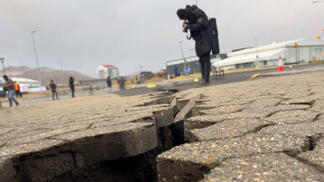
A volcano on southwestern Iceland’s Reykjanes peninsula has begun erupting following weeks of earthquake activity that destroyed homes, broke apart roads and prompted the evacuation of a fishing village.
The eruption started after 10pm local time on Monday, and was located around 3km (2 miles) north of Grindavik, the Icelandic Meteorological Office (IMO) said in a statement. A series of earthquakes began shaking the area about an hour before the volcano erupted.
A Coast Guard helicopter was dispatched to confirm the eruption’s exact location and size when the IMO statement was issued. The 4,000 residents of Grindavik were forced to flee their homes last month, as Icelandic authorities warned that underground magma was getting closer to the surface and could burst through.
Video from helicopter above fissure just broadcast in live news programme #Iceland #volcano pic.twitter.com/3SrH2mN3JK
— Duncan (@shaksper) December 18, 2023When ur on the last already delayed flight back from Iceland and the volcano erupts xox pic.twitter.com/rjEZwHtHe5
— Maymah💜 (@moomie__) December 18, 2023#Iceland #Grindavik from the family in #Hafnarfjördur pic.twitter.com/LmwxQrzSvZ
— Caroline Keep (@Ka81) December 18, 2023The volcano is also located near one of Iceland’s top tourist attractions, the Blue Lagoon geothermal spa, which has largely remained closed since November 9 amid the heavy seismic activity. Grindavik is located about 35 miles southwest of Iceland’s capital, Reykjavik, where the eruption was reportedly visible.
Read more Iceland volcanic eruption looms as tremors rip roads open
A video clip posted on social media purported to show a view of the volcano from a plane preparing to take off from the Keflavik Airport, west of Reykjavik.
The 2010 eruption of the Eyjafjallajokull volcano in southern Iceland spewed huge clouds of volcanic ash into the atmosphere, causing the largest disruption to European airline flights since World War II.

 1 year ago
405


 English (US) ·